GeoModel is the comprehensive 3D reservoir modeling software. Based on the logging interpretation, seismic interpretation and Oilfield geology study results, and specified to one or more reservoir, the software utilizes the advanced computer technology, delineates the change and distribution of geologic characters in 3-Dimension, and applies stochastic simulation and deterministic modeling methods to delineate all geologic parameters such as reservoir frame, lithology and reservoir properties.
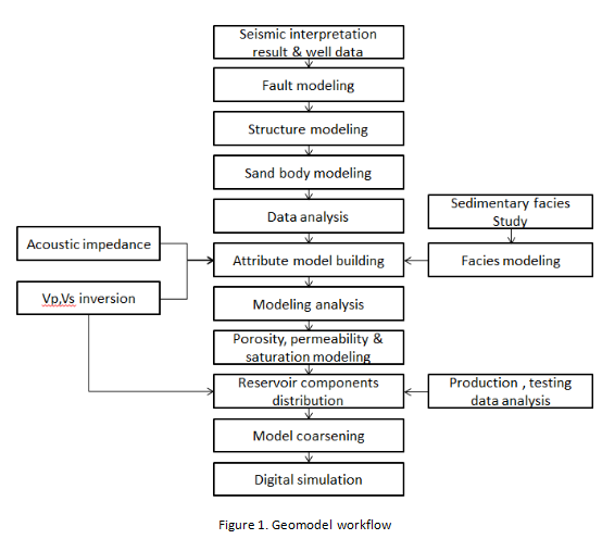
GeoModel workflow
☆Main features
☆Impeccable database management system
GeoModel provides a series of feasible database management functions, it supports a variety of popular database such as Access, SQServer, Oracle, DB2 etc. it can run in standalone or sharing with more than one person, the team members can observe the data changing no matter who modify the result anywhere. The other similar software mainly save the database in document format which make the project becoming redundant. In contrast, database management in Geomodel is more advanced.
☆Structure frame building with multiple methods
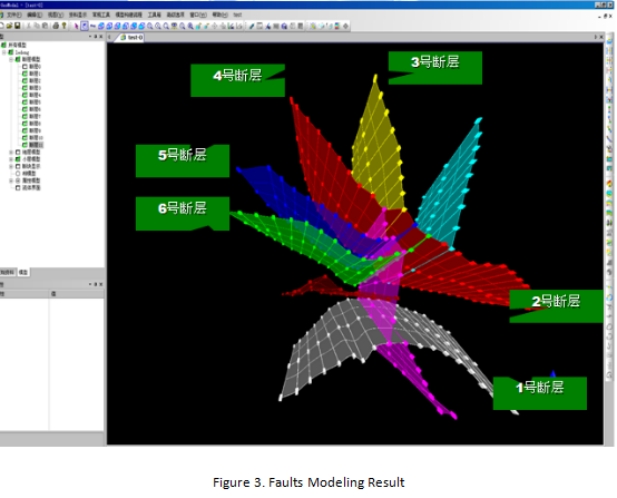
Fault modeling is objective to build the reasonable faults model based on the picked faults data which displays the 3D distribution of faults plane. The main work of fault modeling is to convert the picked faults into gridding faults and layout the cutting relations among faults. Normally, the picked fault is set as polygon data, the GeoModel builds the fault model automatically by computing the center of faults. The other similar software needs more manual work to build the fault model, such as cut or edit the fault data. As there are many faults in one block, even thousands faults in complex block, the manual processing is time waste and inefficiency. GeoModel saves amount of time in this procedure which enhance the efficiency for the fault model building.
GeoModel do the 3D Delaunay split using automatic adaptive split and merge algorithm, which combines with the improved control circle segmentation algorithm, provides automatic adaptive iteration algorithm to control the gridding interpolation around the faults, it also control the gridding density effectively, helps to improve the efficiency of structure modeling. Meanwhile, Geomodel does not have the constraint of fault types in model building and can build complex geological structure model, normal, reverse, vertical faults as well as inter – out boundaries can be processed.
GeoModel supports 3 type layouts of horizons during model building: parallel type: inner layers parallel to top and base layer; offlap-erosion type: inner layer parallel to base layer but crossing with top layer; Overlap type: inner layers parallel to top layer but crossing with the base layer.
☆Multi-methods geological properties model building
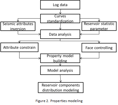
GeoModel adopts the Gslib as the core of properties simulation, using variety of modeling methods of deterministic modeling and stochastic modeling, such as Sequential Gauss, Boolean simulation, Kreager algorithms. Comparing with the other similar software, GeoModel can provide more choices for properties simulation and convenient to users to compare the results from different methods, which improve the simulation quality in some degree. In addition, it can provide the phase controlled properties modeling with input of lithology phase model, seismic attributions model etc.
Comparing with similar software, Gslib provides the inner- interpolation of regular gridding, different with the Laplasse smoothing algorithm which used in the other software, GeoModel used the initial Gslib database and Rectangular grid, in hence to obtain the more accurate model without any correction.
GeoModel provides several deterministic simulation and stochastic simulations to characterize the facies such as Sequential indicator and Kelijinge instructions.
☆Model result analysis
It can provide following functions such as analysis of reserves calculation, reservoir analysis, Reservoir plane analysis, quick well trajectory design, model conversion.
☆Powerful mapping function
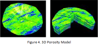
Utilizing 3D graphics processing technology to build the profile and 3D visualization map, dynamically display the 2D, 3D map, slices, Grid chart, 3D Graphics editing function( easily modify the plots) and 3D visualization etc. it can be displayed arbitrarily in any size with zoom in/out using mouse.
